
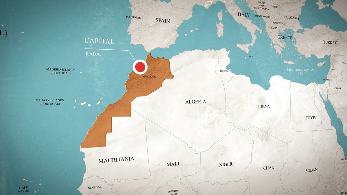
Where is Morocco located? Morocco is in North Africa, at the northwestern edge of the African continent. It faces the Atlantic Ocean to the west and the Mediterranean Sea to the north, while Algeria lies to the east.
Its position is unusual because Morocco sits very close to Europe. At the narrowest part of the Strait of Gibraltar, the Moroccan and Spanish coasts are only about 13 kilometers apart.
This geography helps explain why Morocco feels so varied. Within one country, travelers can move from Atlantic beaches to Mediterranean towns, through the Rif and Atlas Mountains and toward dry landscapes on the edge of the Sahara.
This guide explains where Morocco is located, whether Morocco is in Africa, which countries border Morocco, how to understand a Kingdom of Morocco map and where the Atlas Mountains fit into the country’s geography.
Morocco Location at a Glance
| Question | Answer |
|---|---|
| Continent | Africa |
| Region | North Africa / Maghreb |
| Capital | Rabat |
| Largest city | Casablanca |
| Ocean | Atlantic Ocean |
| Sea | Mediterranean Sea |
| Main eastern land neighbor | Algeria |
| Closest European country | Spain |
| Main mountain systems | Rif, Middle Atlas, High Atlas and Anti-Atlas |
| Highest mountain | Jbel Toubkal – 4,167 m |
Is Morocco in Africa?
Yes. Morocco is in Africa.
More precisely, it lies in the northwestern part of the continent and belongs to the region commonly known as North Africa or the Maghreb.
The Maghreb generally refers to the western part of North Africa and includes Morocco, Algeria and Tunisia, with broader definitions sometimes including Libya and Mauritania.
Morocco’s close connection with Europe sometimes causes confusion for first-time travelers. Spain is visible across part of the Strait of Gibraltar on clear days, and travel between Morocco and southern Europe can be very short.
Geographically, however, Morocco is firmly part of the African continent.
Where Is Morocco on the World Map?
Find the African continent on a world map and move to its upper-left corner. That is where you will find Morocco.
The country occupies a strategic position where several major geographic areas meet:
- The Atlantic Ocean lies to the west.
- The Mediterranean Sea lies to the north.
- Algeria lies to the east.
- Spain lies across the Strait of Gibraltar to the north.
- The Sahara and disputed Western Sahara territory lie toward the south.
The Moroccan National Tourist Office describes the country as being at the crossroads of Europe and Africa, bordered by Mediterranean waters and open to the Atlantic Ocean.
You can see an official overview of the country’s landscapes in the Moroccan National Tourist Office geography guide.
How Close Is Morocco to Europe?
Morocco is one of the African countries closest to Europe.
The Strait of Gibraltar separates northern Morocco from southern Spain and connects the Atlantic Ocean with the Mediterranean Sea.
According to NASA Earth Observatory, the distance between the Spanish and Moroccan coasts is only about 13 km at the narrowest point.
You can see the geography clearly in this NASA view of the Strait of Gibraltar.
This explains why northern Moroccan cities such as Tangier have historically been important links between Africa, Europe, the Atlantic and the Mediterranean.
What Countries Border Morocco?
The question which countries border Morocco requires a little explanation because maps do not always present the southern boundary in exactly the same way.
| Country or territory | Relationship to Morocco |
|---|---|
| Algeria | Shares Morocco’s long eastern land border |
| Spain | Faces Morocco across the Strait of Gibraltar and has land boundaries through Ceuta and Melilla |
| Western Sahara | Lies to the south; its final political status remains unresolved |
| Mauritania | Lies south of Western Sahara; appears as a direct neighbor on maps that incorporate Western Sahara into Morocco |
Morocco and Algeria
Algeria is Morocco’s main land neighbor to the east.
Although the two countries share a long border, travelers should not assume they can simply drive from one to the other. Border access and diplomatic conditions should always be checked using current official information.
Morocco and Spain
Spain is mainly separated from Morocco by sea, but there are also land boundaries around the Spanish-administered cities of Ceuta and Melilla on the North African coast.
This makes Morocco geographically unusual: an African country can be only a short distance from mainland Europe while also having direct land boundary points with Spanish-administered territory.
What About Western Sahara?
This is the main reason different versions of a Kingdom of Morocco map may not look identical.
Morocco claims Western Sahara and administers most of the territory. The United Nations, however, continues to list Western Sahara as a Non-Self-Governing Territory whose final status remains unresolved.
You can check the current international status directly on the United Nations Western Sahara page.
For a simple travel geography article, the important point is that maps may draw or label the southern part of the region differently depending on the cartographic or political convention being used.
Kingdom of Morocco Map: What Should You Look For?
A useful Kingdom of Morocco map should show more than political boundaries.
Look for five important geographic features:
- The Atlantic coastline.
- The Mediterranean coastline.
- The Rif Mountains in the north.
- The Atlas Mountains across the interior.
- The increasingly dry landscapes toward the south and southeast.
The CIA publishes public geographic maps of Morocco, including administrative and physical maps. You can consult the CIA Morocco map collection for a clear geographic reference.
Atlas Morocco Map: Where Are the Atlas Mountains?
Anyone looking at an Atlas Morocco map will notice that mountains form a major part of the country’s geography.
Morocco has several important mountain systems.
The Rif Mountains
The Rif Mountains stretch across northern Morocco close to the Mediterranean.
Chefchaouen sits within this mountainous northern region, which helps explain its steep streets, green surroundings and very different landscape from Marrakech.
If you are planning to visit the north, our complete Chefchaouen guide explains what to see in Morocco’s famous blue city.
The Middle Atlas
The Middle Atlas crosses central-northern Morocco and includes forested landscapes, lakes and higher-altitude towns such as Ifrane.
The Moroccan National Tourist Office describes the range as extending for roughly 350 km.
The High Atlas
The High Atlas is the largest and highest mountain chain in Morocco.
It stretches for approximately 750 km and contains Jbel Toubkal, which reaches 4,167 metres and is the highest mountain in North Africa.
The High Atlas also creates one of Morocco’s major geographic divisions. Routes south from Marrakech toward Ouarzazate, Ait Ben Haddou and the desert must cross this mountain system.
If that landscape interests you, see our Ait Ben Haddou guide.
The Anti-Atlas
The Anti-Atlas lies farther south and has a drier, more rugged character.
As you travel through this region, green northern and coastal landscapes increasingly give way to arid plateaus, rocky valleys and terrain influenced by the nearby Sahara.
Does Morocco Have Both Atlantic and Mediterranean Coasts?
Yes. This is one of the most important features of Morocco’s location.
The Atlantic Ocean forms the country’s long western coastline, while the Mediterranean Sea meets northern Morocco.
Atlantic cities include Casablanca, Rabat, Essaouira and Agadir, while Tangier sits close to the meeting point of Atlantic and Mediterranean waters.
Farther east along the Mediterranean are places such as Al Hoceima and Saidia.
This long coastline has a major effect on Morocco’s climate, economy, food and tourism.
Where Are Morocco’s Main Cities?
| City | Part of Morocco | Known for |
|---|---|---|
| Rabat | Northwest / Atlantic coast | Capital, government and historic sites |
| Casablanca | West / Atlantic coast | Largest city and major business center |
| Marrakech | Central-west, north of High Atlas | Medina, culture and tourism |
| Fes | Northern interior | Historic Medina and traditional crafts |
| Tangier | Far north | Strait of Gibraltar and gateway to Europe |
| Chefchaouen | North / Rif Mountains | Blue Medina and mountain setting |
| Agadir | Southwest / Atlantic coast | Beaches and coastal tourism |
| Ouarzazate | Southeast of High Atlas | Desert routes, cinema and kasbah landscapes |
Where Is Marrakech in Morocco?
Marrakech is located in the central-western part of Morocco, north of the High Atlas Mountains.
Its position makes it useful for travelers because very different landscapes can be reached from the city.
You can spend one day exploring the Medina and then travel toward mountain valleys, Agafay, Essaouira or the route through the High Atlas toward Ouarzazate.
For ideas inside the city, see our guide to the 10 best things to do in Marrakech.
Is Morocco Part of the Middle East?
Geographically, Morocco is in North Africa, not the Middle East.
However, Morocco is often included in broader political, cultural or economic groupings described as the Middle East and North Africa, commonly abbreviated as MENA.
This can cause confusion.
If the question is simply geographic, the answer is clear: Morocco is an African country located in North Africa.
Is Morocco an Arab Country?
Morocco is often described as both an Arab and Amazigh country, but geography and cultural identity are different questions.
Arabic and Amazigh are the country’s official languages, while Moroccan Arabic, or Darija, is widely used in daily life.
If you want to understand the language situation before traveling, read our guide to languages spoken in Morocco.
How Big Is Morocco?
Published area figures can differ depending on whether a source includes Western Sahara within Morocco’s total territory.
For this reason, when comparing a Morocco map or country statistics, check how the source treats the disputed territory before comparing total area numbers.
A more useful fact for travelers is how geographically varied the country is. Morocco stretches from Mediterranean and Atlantic coastlines through forested and high mountain regions toward much drier southern landscapes.
Morocco’s Population
Morocco’s official 2024 census counted 36,828,330 people.
The population is concentrated heavily in cities and along the Atlantic and northern regions, although communities are found throughout mountain, oasis and southern areas.
For current demographic figures, the Moroccan High Commission for Planning is the country’s official statistical authority.
Why Morocco’s Location Matters for Travelers
Morocco’s position explains why a relatively short trip can contain very different experiences.
| Geographic area | Travel experience |
|---|---|
| Atlantic coast | Casablanca, Rabat, Essaouira, Agadir and beaches |
| Mediterranean north | Tangier, Tetouan, Al Hoceima and coastal scenery |
| Rif Mountains | Chefchaouen and northern mountain landscapes |
| Middle Atlas | Forests, lakes, Ifrane and mountain towns |
| High Atlas | Toubkal, valleys, villages and mountain routes |
| Southern Morocco | Kasbahs, oases, rocky plateaus and desert routes |
Where Should You Arrive in Morocco?
The best entry city depends on your itinerary rather than simply the location of Morocco on a map.
Casablanca works well for broader country itineraries and international connections.
Marrakech is convenient for travelers focused on the Red City, the High Atlas and southern routes.
Tangier makes sense for northern Morocco and journeys connected with Spain.
Fes is useful for historic northern and central routes, while Agadir works well for Atlantic beaches and southern coastal travel.
You can compare different routes through our Morocco tours or create an itinerary around your arrival city with our custom Morocco tour.
Planning a Morocco Trip Around the Map
Distances in Morocco can be misleading when looking only at a map.
A route may appear short but involve mountain roads, while high-speed and conventional rail make some northern and Atlantic-city journeys relatively simple.
For a first trip, it is often better to choose one or two regions instead of trying to cover the entire country in a few days.
For example:
- Marrakech + High Atlas for a short cultural and mountain trip.
- Casablanca + Rabat + Fes for cities and history.
- Tangier + Chefchaouen + Fes for northern Morocco.
- Marrakech + Ouarzazate + Merzouga for a longer southern route.
Frequently Asked Questions About Morocco’s Location
Where is Morocco located?
Morocco is located in North Africa, at the northwestern corner of the African continent. It faces the Atlantic Ocean to the west and the Mediterranean Sea to the north.
Is Morocco in Africa?
Yes. Morocco is an African country and part of the North African region known as the Maghreb.
Is Morocco close to Europe?
Yes. At the narrowest part of the Strait of Gibraltar, the Spanish and Moroccan coasts are only about 13 km apart.
What countries border Morocco?
Algeria shares Morocco’s eastern land border. Spain has land boundaries with Morocco through Ceuta and Melilla. Western Sahara lies to the south and has an unresolved international status. Maps incorporating Western Sahara into Morocco also show Mauritania as Morocco’s southern neighbor.
Is Morocco in the Middle East?
No geographically. Morocco is in North Africa. It is sometimes grouped with Middle Eastern countries under the wider MENA term.
What ocean is Morocco on?
Morocco faces the Atlantic Ocean along its western coast and the Mediterranean Sea along its northern coast.
Where are the Atlas Mountains in Morocco?
The Atlas system crosses much of central and southern Morocco. The High Atlas runs south of Marrakech and includes Jbel Toubkal, the highest peak in North Africa at 4,167 metres.
What is the capital of Morocco?
Rabat is the capital of Morocco. Casablanca is the country’s largest city and one of its main economic centers.
Final Answer: Where Is Morocco Located?
Morocco is located in northwestern Africa, between the Atlantic Ocean and the Mediterranean Sea and only a short distance from southern Europe.
Its position helps explain much of what travelers see: Mediterranean towns in the north, long Atlantic coastlines in the west, the Rif and Atlas Mountains through the interior and increasingly arid landscapes toward the south.
Understanding the map also makes planning easier. Tangier makes sense for a northern route, Marrakech for the High Atlas and southern journeys, and Casablanca or Rabat for travel along the Atlantic corridor.
If you are starting to organize a trip and are unsure which regions fit your available time, you can create a tailor-made Morocco itinerary or contact us with your dates, arrival city and the places you want to see.